“Extremely dangerous” thunderstorms hit Toronto and brought heavy rain, golf ball-sized hail, and destructive winds, causing widespread flooding, large power outages, and downed trees and wires.
The storm quickly flooded major roads, catching drivers by surprise as several had to be rescued from their submerged vehicles.
Destructive winds downed power lines and trees and blew off roofs of several buildings.
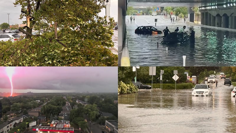
The powerful storms led to emergency alerts being sent to phones and broadcast on TVs and radios, advising residents to seek shelter indoors.
Thunderstorms also rolled through other parts of southern Ontario, prompting Environment Canada to issue numerous weather advisories, including tornado red warnings.
An Environment Canada meteorologist told CTV News Toronto earlier that there was a “good chance” of one or two brief tornado reports from across southwestern Ontario or southern Ontario.
Key details:
- As of 8 p.m., Toronto Hydro says 45,000 customers are still without power
- Emergency services across the GTA are responding to widespread flooding on roads and highways.
- The DVP is closed, as well as parts of Allen Road, Lake Shore Boulevard West, and Gardiner Expressway.
- All weather alerts for Toronto have been lifted.
- IN PHOTOS: Toronto hit by thunderstorm
The live blog has ended. Here’s a recap of today’s events:
Viewer video shows TTC bus flooded
A CP24 viewer sent a video showing floodwater rushing into a TTC bus they were on.
Passengers can be seen raising their feet off the floor to avoid getting wet as water fills the bus.
According to the viewer, it happened around 5:30 p.m. near Sheppard Avenue West as they were on a southbound 7 Bathurst bus.
Bryann Aguilar, CP24.com journalist
45K still without power
Toronto Hydro says it has restored power to 20,000 customers, and crews are still working to get the electricity of the remaining 45,000 who remain in the dark.
“Safety remains our top priority as crews respond to reported hazards, including downed powerlines and damaged electrical equipment, while restoring service as safely and quickly as possible,” a Toronto Hydro spokesperson said in an update.
“We have added additional resources to support customers as we experience high call volumes and remain committed to supporting those impacted by the storm and keeping customers informed throughout the restoration effort.
At the peak of the outage, about 65,000 customers were without power.
Bryann Aguilar, CP24.com journalist
CNE closes early
In an Instagram post, officials with the Canadian National Exhibition said the fair will close its doors early due to severe weather conditions.
“Due to ongoing severe weather conditions impacting the operation of the CNE and for the safety of our staff, partners, and guests, we will be closing the grounds at 7 p.m. and buildings at 8 p.m.”
BRKN Love and Finger Eleven were also scheduled to perform at the Bell Soundstage at the Bandshell, but those performances have since been cancelled as a result.
Joshua McGinnis, CP24.com journalist
DVP, other major Toronto roads closed due to flooding
The Don Valley Parkway is closed in both directions due to flooding, Toronto police say.
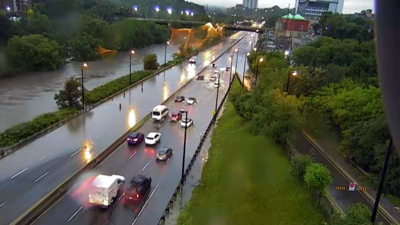
The highway, which runs east of the Don River, is closed between Bayview/Bloor and the Gardiner Expressway as well as between Jarvis Street and Bloor Street.
Toronto police say southbound lanes of Allen Road at Lawrence Avenue are closed as well as the eastbound lanes of the Gardiner Expressway at Jarvis Street.
They add that sections of the Bayview Avenue Extension are also shut down due to flooding.
Lake Shore Boulevard West is also closed from Strachan Avenue to British Columbia Road, the city says.
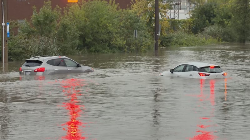
Widespread flooding has been reported on many roads in the city and in other parts of the Greater Toronto Area.
Peel police are urging drivers to avoid Southdown Road and Bromsgrove Road in Mississauga due to flooding under the bridge.

They say some vehicles were stuck in the flood.
York Regional Police say the intersections of Jane Street and Highway 7, Rutherford and Vaughan Mills Roads, and Rivermede and Bowes Roads are closed due to “severe flooding.”
“Please avoid the area, do not attempt to drive through flooded roads,” police said in their social media post.
Bryann Aguilar, CP24.com journalist
Toronto hospital experiencing flooding
Michael Garron Hospital says its emergency department is experiencing flooding but remains open and operational.
“We appreciate your kindness and patience as our team does their best to provide urgent care for patients as safely and quickly as possible,” the hospital said in a post on Instagram.
Bryann Aguilar, CP24.com journalist
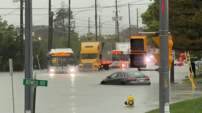
Trucks, buses submerged in Vaughan
An industrial neighbourhood in Vaughan turned into a river as heavy rains flooded the roads, submerging cars, trucks, and transit buses.
Images show dozens of vehicles were stuck in the area of Rivermede and Bowes roads.
There were reports that Vaughan emergency crews rescued multiple people, including children, from submerged vehicles.
Bryann Aguilar, CP24.com journalist
Major flooding reported in Scarborough
Major flooding has been reported on Scarborough Golf Club Road, where a stretch of the road is currently under construction.
The road between Lawrence Avenue and Ellesmere Road is flooded following heavy rainfall.
One resident said the road has been under construction for years, but conditions this year have been particularly bad.
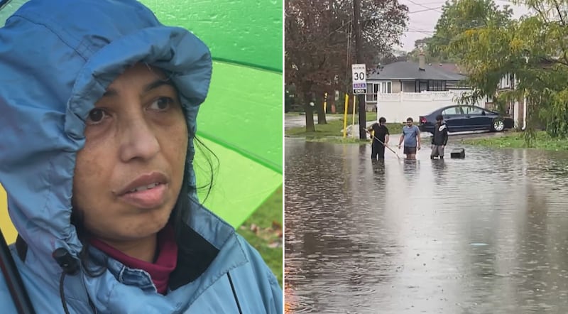
“I think it’s a dangerous situation, right? It’s impacting travelling, going here, going there,” the resident said.
“Whenever the rain happens, this flooding happens here.”
Joshua McGinnis, CP24.com journalist
65K Toronto Hydro customers in the dark
Approximately 65,000 residents across Toronto are currently without power, according to Toronto Hydro.
“This is an evolving situation and we want customers to know that crews are actively responding across the city,” a Toronto Hydro spokesperson said in a statement.
“The safety of our customers, employees and the public remain our top priority. We are responding to reported hazards, including downed powerlines and damaged electrical equipment, while coordinating restoration efforts across the city.”
Residents in neighbourhoods including Scarborough, Etobicoke, Toronto Centre and East York are among those experiencing outages.
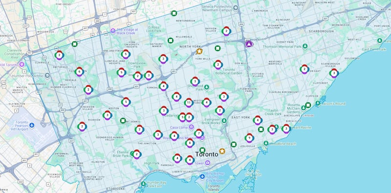
Toronto Hydro said crews are assessing storm-related damage, making emergency repairs and working to restore power “safely and as quickly as possible.”
“Given the scale of the storm and the number of outages, restoration efforts may take time and vary by location,” the utility company said. “Additional storms are forecast throughout the evening, which may impact restoration efforts.”
Estimated restoration times vary depending on the neighbourhood. Residents can check the Toronto Hydro outage map for the latest information on outages and estimated restoration times.
Joshua McGinnis, CP24.com journalist
Vehicles submerged in flooded downtown underpass
Multiple vehicles are stuck in downtown Toronto after heavy rain flooded an underpass.
A CP24 camera caught at least two vehicles submerged in flood water in the Lower Simcoe Street underpass near Bay and Lower Simcoe streets.
Police are seen assisting the occupants of the vehicle to safety.
Joshua McGinnis, CP24.com journalist
Roof collapse in North York
Toronto Fire Services (TFS) say six people evacuated a building in North York after its roof collapsed during a thunderstorm.
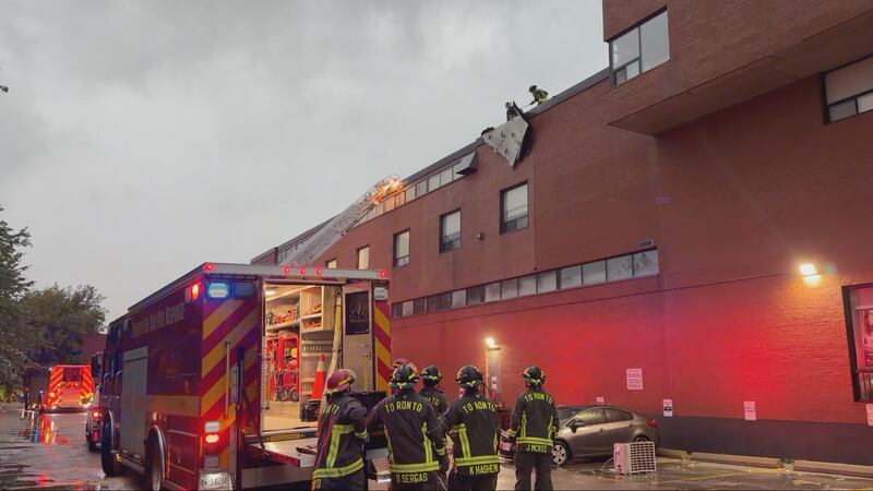
Crews responded to a building on Lawrence Avenue West, east of Caledonia Road, and found the roof had been blown off.
TFS says crews located two people who were not injured while four others exited the building on their own.
Bryann Aguilar, CP24.com journalist
TTC reports weather-related delays
The TTC says trains are currently not stopping at St. Patrick Station and northbound at Union Station towards Finch due to flooding.
Trains are also not running between Wilson and Sheppard West stations, as the TTC handles an “operational problem,” adding shuttle buses are on the way.
There is also no service on Line 6 Finch West due to “debris on tracks.”
“As inclement weather continues, we’re closely monitoring conditions and making service adjustments as required,” the TTC said in a social media post.
Alex Arsenych, CTV News Toronto journalist
TLC and Salt-N-Pepa rescheduled
After initially saying it would proceed, organizers say tonight’s TLC and Salt-N-Pepa concert at RBC Amphitheatre has been rescheduled to Sept. 11.
Organizers cited severe weather as the reason for the postponement.
“More information will be shared directly with ticket purchasers,” the post reads.
Alex Arsenych, CTV News Toronto journalist
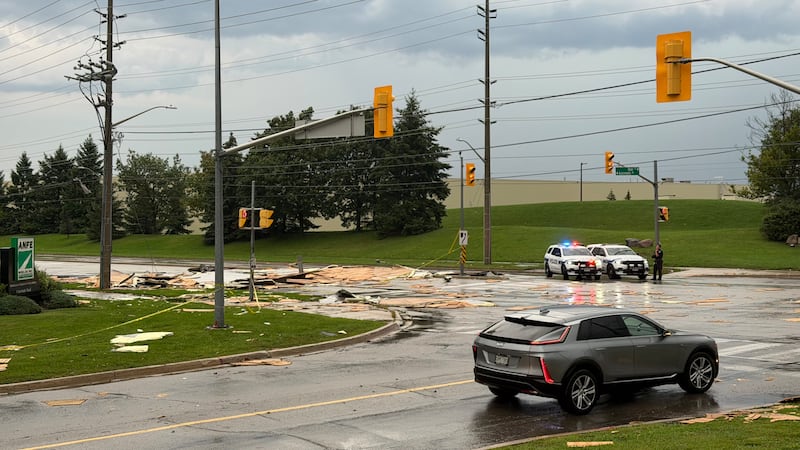
Roof of Brampton building blown off
The roof of a building in Brampton is gone after destructive winds blew it off during a thunderstorm.

Debris is seen scattered across the road near Williams Parkway between Sun Pac Boulevard and Airport Road.
No injuries were reported.
Police say they remain on the scene to ensure public safety and monitor debris on the roadway.
Bryann Aguilar, CP24.com journalist
Tornado watches for Hamilton, Burlington, Oakville
Tornado watches are in effect for various regions outside of the Greater Toronto Area, including Hamilton, Burlington and Oakville, as weather officials warn of a severe thunderstorm pushing across Lake Huron.
Environment Canada issued a tornado watch for the City of Hamilton at 5:43 p.m. Wednesday, saying “conditions are favourable for the development of severe thunderstorms which may produce a tornado.”
The weather agency is warning of several other hazards, including strong and possibly damaging wind gusts in excess of 110 km/h, quarter- to loonie-sized hail and torrential downpours “over the next several hours.”
“Significant damage or destruction to infrastructure, homes and the natural environment is possible,” Environment Canada adds, sharing safety tips here.
Tornado watches are also in effect Wednesday evening for Burlington/Oakville, Halton Hills-Milton, Brantford, Guelph, Kitchener-Cambridge-Waterloo, London, Strathroy and Woodstock, according to Environment Canada’s weather alerts page.
Ethan Morneau, CTVNews.ca national digital producer
What is fueling these thunderstorms?
“This is a bit of a rare, unique situation that’s unfolding in the city of Toronto,” CTV News weather anchor Lyndsay Morrison says.
She notes that the severe thunderstorm red warning has been downgraded, but an orange watch still remains. Morrison adds that another round of thunderstorms could develop this evening.
Morrison also points out that tornado warnings are in effect for other parts of southern Ontario.
“This is very much a dynamic, developing situation around southern Ontario, different thunderstorms impacting different areas,” she says.
Morrison notes that “all ingredients” for thunderstorm activity were present today.
“It is hot. It’s humid. We’ve got strong wind shear, and we’ve got this cold front that will continue to bring thunderstorm activity to us here in the GTA at least through the early part of the evening,” she says.
Bryann Aguilar, CP24.com journalist
Numerous power outages reported across Toronto
Multiple power outages have been reported across Toronto, leaving thousands of residents without electricity.
The outage areas appear to span a broad swath of the city, including Toronto’s west end, downtown, and north end, as well as pockets in the southwest.
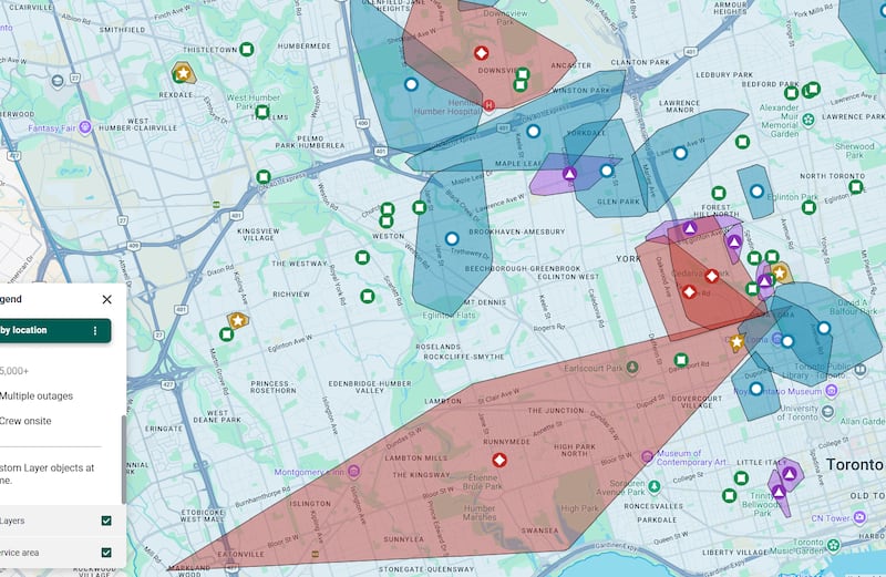
One outage stretches from Bloor Street West to St. Clair Avenue and Spadina Road, affecting a total of 6,794 customers.
Estimated restoration times currently range from 10 to 11 p.m., depending on the neighbourhood.
For more information on current outages, visit the Toronto Hydro outage map.
Joshua McGinnis, CP24.com journalist
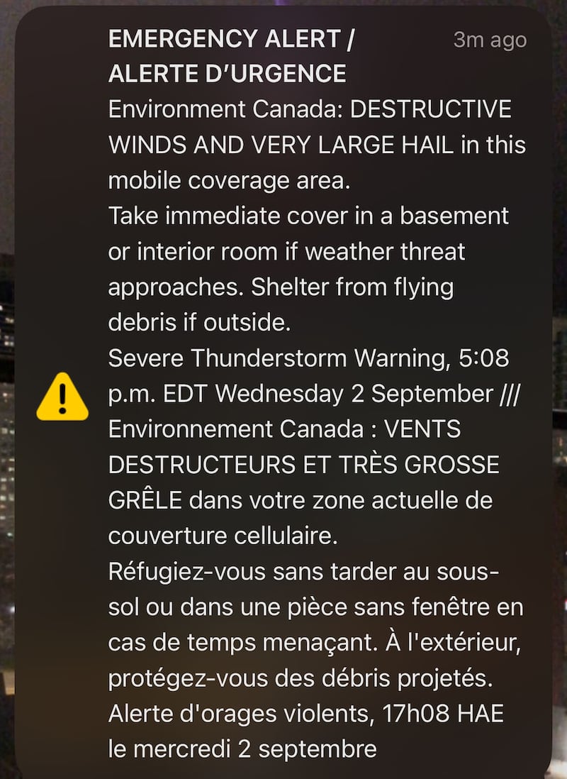
Emergency Alert sent to phones
Toronto residents have received an emergency alert on their mobile phones, warning them of “destructive winds and very large hail” due to the thunderstorm.
“Take immediate cover in a basement or interior room if a weather threat approaches. Shelter from flying debris if outside,” the alert reads.
Bryann Aguilar, CP24.com journalist
Multiple reports of downed wires, fallen trees
Toronto police say they have received several reports of downed wires and fallen trees throughout the city, and are urging motorists to be careful on the roads.
“Slow down, and drive according to the road conditions,” police wrote in a post on social media, adding that drivers should take extra time to get to their destinations.
Alex Arsenych, CTV News Toronto journalist
Red warning now in effect for Toronto
Environment Canada has issued a severe thunderstorm red warning for Toronto and parts of the GTA.
Meteorologists are tracking an “extremely dangerous thunderstorm” last located over Black Creek Pioneer Village, Environment Canada says.
It is moving southeast at 40 km/h and the areas impacted include North York, Toronto Island, and Scarborough.
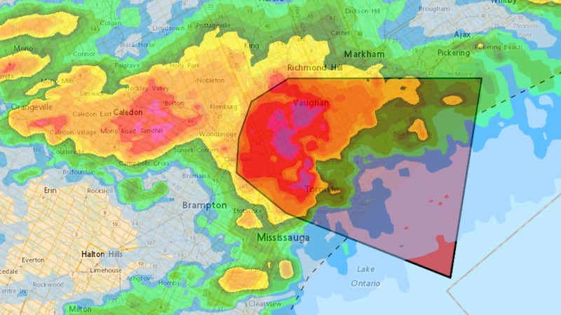
“Destructive wind gusts, baseball-sized or greater hail and very heavy rain are possible,” the federal agency says.
“Take immediate cover if a thunderstorm approaches. If outside, protect yourself from flying debris and hail.”
Bryann Aguilar, CP24.com journalist
TTC not diverting many routes due to weather
Though rain is pelting Toronto, the TTC says it doesn’t have too many routes that are being diverted because of it. However, the transit commission says it is taking precautions in case the weather conditions deteriorate.
“We will be diverting around low-lying areas to avoid flooding, and we will have TTC employees staffed at key locations to monitor the weather and adjust service as needed,” TTC’s Zahra Sherazee told CP24.
“They’re also going to make sure that the floors and platforms remain free of water, and we will have operators driving slowly on open roads—not slowly but reducing their speed on open roads and on the open-cut areas of the subway platforms.”
There is currently one stop along Line 6 that has debris on the tracks, Sherazee noted, temporarily halting service between Finch West and Humber College stations.
Alex Arsenych, CTV News Toronto journalist
Red warnings for tornado in southwestern Ontario
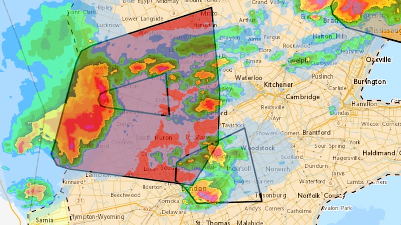
Some areas in southwestern Ontario are under red warnings for tornado and severe thunderstorms this afternoon.
Environment Canada says a thunderstorm capable of producing a tornado was located near Clinton, Ont., at 4:50 p.m.
“This is a very dangerous and potentially life-threatening situation,” Environment Canada says.
The thunderstorm is moving quickly to the east at 75 km/h and impacted area include Clinton, Vanastra, Brucefield, Kinburn, Egmondville, Seaforth, Dublin, Brodhagen, and Mitchell.
Bryann Aguilar, CP24.com journalist
Yellow warning issued again for parts of GTA
Environment Canada has issued a severe thunderstorm yellow warning for Toronto, Mississauga, Brampton, Richmond Hill, Vaughan, and Markham.
The federal agency says a severe thunderstorm located over Bolton at 4:29 p.m. is moving southeast at 40 km/h.
“Damaging wind gusts, loonie-to-ping-pong-ball-sized hail, and very heavy rain are possible,” Environment Canada says.
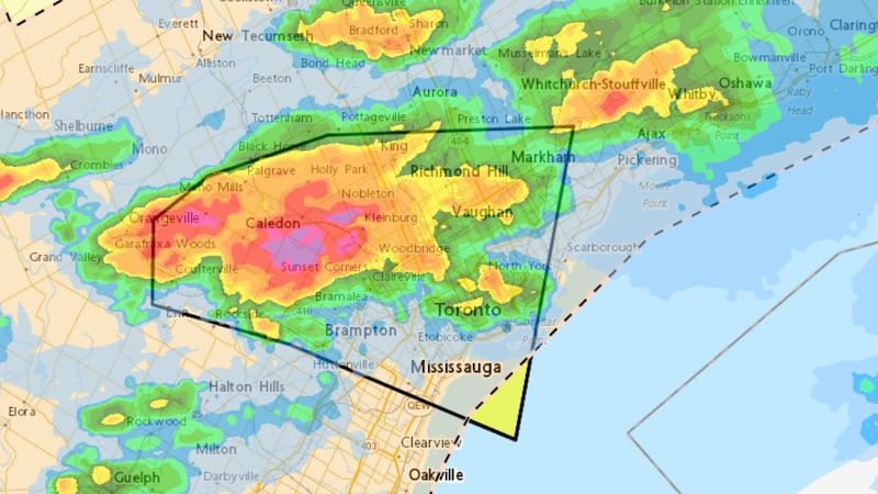
Bryann Aguilar, CP24.com journalist
No major collisions on highways reported due to weather
Police are reminding drivers to proceed with caution on Ontario highways and remain vigilant for flooding and excess water.
In an interview with CP24, OPP Sgt. Kerry Schmidt said there have been no major collisions due to the heavy rain but is reminding drivers to “watch your speed, take it easy, slow down when you see that water in front of you, and don’t be chasing puddles.”
Joshua McGinnis, CP24.com journalist
Delays and cancellations possible at Pearson airport
Toronto Pearson officials are urging passengers to check their flight status before coming to the airport, as delays and cancellations are possible due to the weather.
“Air traffic management initiatives are currently in place due to active weather affecting Toronto Pearson and the surrounding area,” Pearson said in a post on social media.
Bryann Aguilar, CP24.com journalist
Yellow warning ends, orange watch remains
Environment Canada says a severe thunderstorm yellow warning for Toronto has ended, but the orange watch advisory is still in effect.
The warning was issued earlier as thunderstorms bringing heavy rain and strong winds rolled through the city.
Bryann Aguilar, CP24.com journalist
Flooding reported on Highway 404 after heavy rainfall
Heavy rainfall has caused flooding on Highway 404 near the Steeles Avenue on-ramp in Markham.
OPP Sgt. Kerry Schmidt said a vehicle became stuck due to the flooding, and as a result, the southbound on-ramp is closed.
An Ontario 511 traffic camera image captured at 3:26 p.m. shows vehicles navigating the flooded ramp.
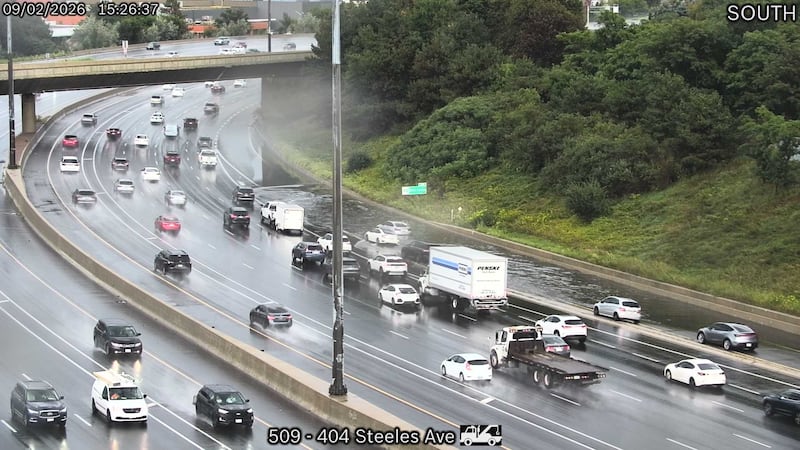
Joshua McGinnis, CP24.com journalist
Another thunderstorm in the city’s west end
A second thunderstorm, which was located over Brampton at 3:26 p.m. and moving east at 55 km/h, is approaching Toronto.
“Strong wind gusts, up to quarter-size hail, and heavy rain are possible,” Environment Canada says.
As of 3:32 p.m., the other thunderstorm that was over Scarborough is now in Pickering and continues to move east.
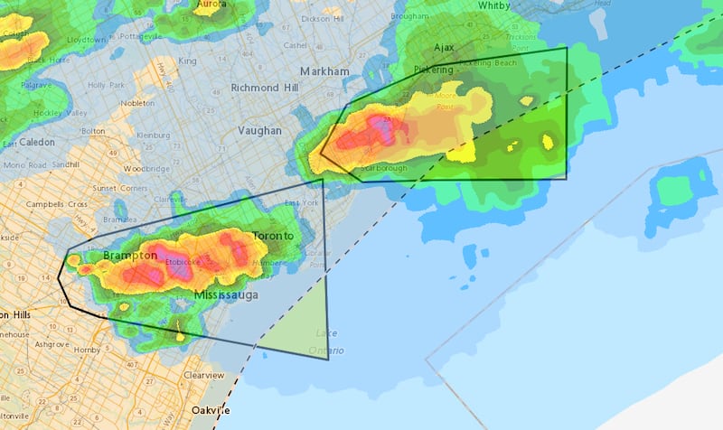
Bryann Aguilar, CP24.com journalist
Severe thunderstorm now in Scarborough
A severe thunderstorm that developed north of Toronto earlier this afternoon has arrived in the city’s east end, bringing damaging wind gusts and heavy rain.
A yellow warning for severe thunderstorm is now in effect for parts of the city, including North York and Scarborough, as well as some areas in Durham Region with the storm continuing to move east.
Bryann Aguilar, CP24.com journalist
Severe thunderstorm over Vaughan
Environment Canada says a severe thunderstorm is located over Vaughan as of 2:51 p.m.
“This severe thunderstorm is moving east at 55 km/h. Damaging wind gusts, loonie-to-ping-pong-ball-sized hail, and heavy rain are possible,” the federal agency says.
A yellow warning is currently in effect for Vaughan, Nobleton, Kleinburg, Woodbridge, King City, Aurora, Black Creek Pioneer Village, Oak Ridges, Richmond Hill, and Vandorf.
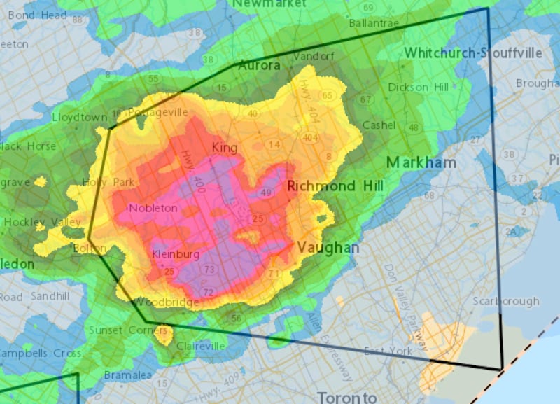
“Local utility outages are likely. Damage to roofs, fences, soft shelters, or trees is likely. Heavy rain may cause flash flooding and significant reductions to visibility. Large hail may cause significant damage and injury. There is a risk of injury,” Environment Canada says.
Bryann Aguilar, CP24.com journalist
Thunderstorms approaching Toronto
Environment Canada says they are monitoring several severe thunderstorms, including one in York Region.
At 2:32 p.m., one of the thunderstorms was located over Bolton, moving east at 60 km/h.
According to Environment Canada, these locations and nearby areas could be impacted: Caledon East, Palgrave, Caledon, Mono Road, Cedar Mills, Sandhill, Bond Head, Lloydtown, Bolton, Schomberg.
Those areas remain under a yellow warning.
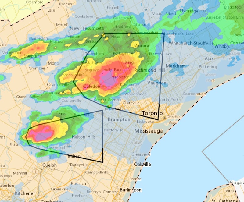
The other thunderstorm was located near Rockwood, Ont., at 2:38 p.m.
Impacted areas include Halton Hills, Georgetown, and Milton.
Bryann Aguilar, CP24.com journalist
Flooding possible in Toronto watersheds
The Toronto and Region Conservation Authority (TRCA) has issued a flood watch for the area, warning that some watersheds have already seen as much as 59 mm of rainfall.
“Heavy rain from thunderstorms in a short time could cause flash flooding and water to pool or collect in flood plains and low-lying areas that do not drain well, especially if significant amounts of rainfall is received over a short duration,” the group said, adding that some areas saw 55 mm of rain accumulation on Tuesday.
Rivers in Carruthers and Duffins watersheds (which are within Durham Region and eastern parts of York Region and Toronto) are likely to rise “well above normal water levels” if more rainfall occurs, the group warned.
Phil Tsekouras, CTV News Toronto journalist
TTC preparing for storm
The TTC says it is prepared to adjust service later today based on weather and road conditions.
In a statement, the transit agency says it is monitoring the weather and coordinating closely with city partners.
The TTC says in the event of heavy rain or strong winds, it will ask operators to reduce speed, monitor subway and streetcar tracks for flooding, deploy staff to key locations, and divert buses or streetcars in low-lying areas where there is flooding.
The transit agency adds that it will also ensure entrances, concourses, and outdoor platforms are free of water.
The TTC notes that the increased service to the CNE will continue as planned.
Bryann Aguilar, CP24.com journalist
Thunderstorm warning north of Toronto
Many parts of York Region, including Newmarket, Vaughan, and Richmond Hill, are under a yellow warning.
According to Environment Canada, as of 2 p.m., a line of severe thunderstorms has been located from Bradford to Tottenham and then to Shelburne and is moving east at 45 km/h.
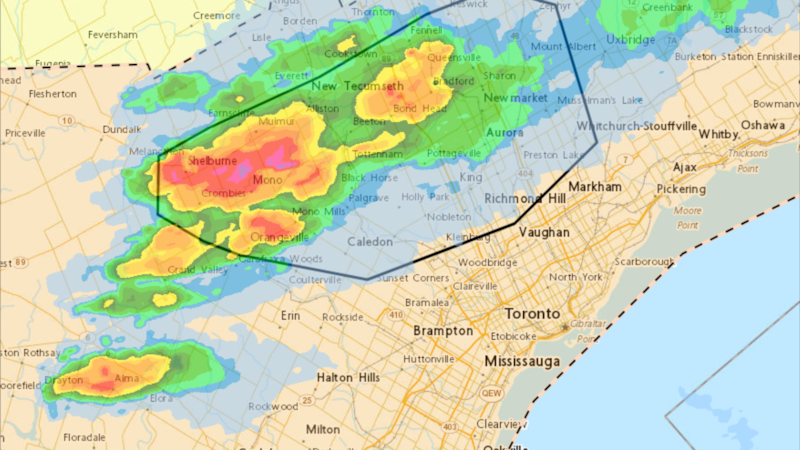
“Damaging wind gusts, loonie-to-ping-pong-ball-sized hail, and heavy rain are possible,” Environment Canada said.
“Severe thunderstorm warnings are issued when imminent or occurring thunderstorms are expected to produce damaging hail, wind or rain. Severe thunderstorms can produce tornadoes.”
Bryann Aguilar, CP24.com journalist
Toronto activates emergency operations centre
The City of Toronto has activated its emergency operations centre ahead of the inclement weather.
Toronto Mayor Olivia Chow said the emergency centre was activated due to “major” rainfall that is expected over the 24 hours.
“City divisions and agencies, including transportation, shelter services, @TTChelps and emergency services are working together to monitor the situation and keep Torontonians safe,” Chow wrote in a post on social media on Wednesday morning.
“We have a plan and it’s underway. If you or someone you know is in danger, call 911.”
Codi Wilson, CP24.com journalist
Air Canada warns of delays at Pearson, Billy Bishop airports
Air Canada says flights at both Toronto Pearson International Airport and Billy Bishop Airport may be impacted by the storms.
“Air Canada is monitoring the situation closely and is working to get you on your way safely and as quickly as possible,” the airline said in a post on its website.
Travellers are encouraged to check their flight status before heading to the airport to see if their trip is affected.
Phil Tsekouras, CTV News Toronto journalist
Possible disruptions for Hydro One customers
Hydro One issued a statement Wednesday morning, warning of possible disruptions to service.
“There is a risk of severe thunderstorms accompanied by high winds forecasted for parts of southern, central and eastern Ontario later today, along with the risk for tornados in some areas,” the statement read.
“Customers are encouraged to prepare for potential power outages.”
Codi Wilson, CP24.com journalist
Storms expected to roll in around 3:30 p.m.
CP24 Meteorologist Bill Coulter said the storms are expected to arrive at around 3:30 p.m. and will linger until around 8 p.m.
“When that cold front comes down later today ahead of it and along it we are going to see some very strong storms,” he said.
While thunderstorms are possible for parts of southwestern Ontario on Thursday but conditions should be clear in the GTA, Coulter said.
Toronto will see a high of 28 C on Wednesday, feeling closer to 36 when factoring in the humidity.
Thursday will see sunshine and high of 27 C.
“Bright and beautiful” weather is on tap for Friday, Saturday, and Sunday, Coulter said.
Codi Wilson, CP24.com journalist