Heavy rains combined with strong winds and seasonal high tides—or “king tides”—have prompted flood warnings from officials on British Columbia’s south coast.
The Vancouver Board of Parks and Recreation is urging residents to watch out for large waves and flooded areas around the city’s beaches and seawalls.
The parks department says the seasonal king tides, which occur when the sun and moon align to exert higher gravitational forces on the Earth’s oceans, are expected to last until Nov. 16.
“Stay safe, enjoy the view from high ground,” the parks board said in a social media post.
In years past, the municipal government has temporarily closed the Stanley Park seawall to pedestrians and cyclists in preparation for similar tidal surges.
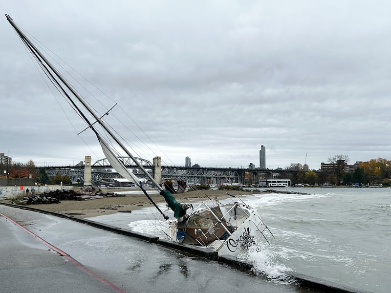
At least one sailing vessel in Vancouver’s English Bay appeared to have fallen victim to the storm surge Thursday as it crashed against the seawall near Sunset Beach.
Environment Canada says several storm systems are moving through the coastal B.C. region, bringing heavy precipitation and localized flooding in some areas.
The weather office issued a coastal flood warning for parts of Haida Gwaii on Thursday, where wind and waves were expected to send water levels surging to 50 centimetres above typical high tide levels.
Special coastal flooding statements were also issued for the coastal Metro Vancouver region from West Vancouver down to Tsawwassen.
“The timing of the strong winds with high tide will result in a potential storm surge with water levels higher than the highest astronomical tide,” the agency warned Thursday.
“Roads and walkways may be difficult to navigate due to flooding and/or debris, such as driftwood and rocks.”
Farther inland, rainfall warnings were issued Thursday afternoon for northeastern Metro Vancouver communities, including Coquitlam and Maple Ridge, where between 40 and 60 millimetres of rain was forecast to fall.
“Water will likely pool on roads and in low-lying areas,” Environment Canada warned ahead of the evening commute. “Landslides may occur in vulnerable areas such as steep slopes, deforested areas or recent burn scars.”
The B.C. River Forecast Centre predicts the series of incoming storms will raise water levels in coastal areas, including western Vancouver Island, Howe Sound and the North Shore.
A high streamflow advisory has been issued for those areas along with a warning that the heavy precipitation will bring increased risks of unstable riverbanks, erosion, landslides and swift-water hazards.

