A stubborn heat dome continues to drive dangerous temperatures across much of Canada, with millions of people under heat alerts as forecasters warn the oppressive conditions are expected to persist.
Environment and Climate Change Canada has issued heat warnings across parts of Ontario, Quebec, the Prairies and the Northwest Territories as daytime highs and humidex values climb well above seasonal norms.
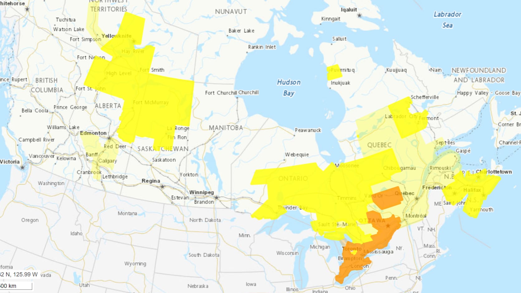
Heat stretches across central and eastern Canada
Ontario remains one of the hardest-hit provinces, with heat warnings covering large portions of the province as hot, humid conditions continue.
Conditions are also expected to remain uncomfortable in southwestern Ontario, where communities continue to deal with elevated daytime temperatures and little overnight relief.
Eastern Ontario is also under the grip of the prolonged heat event, with residents urged to limit outdoor activity during the hottest parts of the day.

Meanwhile, southern Quebec continues to experience sweltering conditions as heat warnings remain in place for several areas.
The hot weather is also combining with unstable atmospheric conditions in parts of Northern Ontario, where some communities are facing the added threat of severe thunderstorms.
Much of the Martimes are also under heat and “severe” thunderstorm warnings.
New Brunswick residents have been warned about “risk of a tornado” by the weather agency, paired with humidex values touching 40 or higher.
Nova Scotia and P.E.I. residents are cautioned about “warm and increasingly humid air mass” in the forecast.
What the alert colours mean
Environment and Climate Change Canada issues a colour-coded weather alert system to better communicate the level of risk associated with hazardous weather.
A yellow alert signals a moderate weather event that could result in localized or short-term impacts, including an increased risk of heat-related illness, disruptions to outdoor activities and additional strain on vulnerable people, animals and power systems.

An orange alert indicates a more significant event that is expected to be widespread or last several days. During prolonged heat, officials warn of a higher risk of illness, pressure on electrical infrastructure, potential water shortages and disruptions to outdoor work and events.
A red alert is reserved for rare, exceptionally dangerous weather events that pose widespread and prolonged risks to public safety. During an extended heat emergency, authorities warn of extreme health risks, significant impacts on infrastructure and major disruptions to essential services.
Warnings differ from watches and advisories
Heat warnings are issued when forecast temperatures or humidex values are expected to reach levels that could affect people’s health. Environment and Climate Change Canada generally issues them 18 to 24 hours before an extreme heat event begins.
A watch is issued when conditions are favourable for severe weather, such as severe thunderstorms or tornadoes, to develop.
An advisory is used for weather that may cause inconvenience or localized impacts but does not meet warning criteria, including hazards such as fog, frost or freezing drizzle.

Officials continue to urge Canadians living in areas under heat warnings to stay hydrated, avoid strenuous outdoor activity during peak afternoon hours and check regularly on older adults, young children and anyone who may be especially vulnerable to extreme temperatures.

