Toronto Pearson International Airport is warning of possible flight disruptions as the city braces for overnight temperatures set to feel like -25 C.
In a statement released Tuesday afternoon, the airport said that weather systems across Canada may impact flights at Toronto Pearson and urged travellers to check their flight status before they depart.
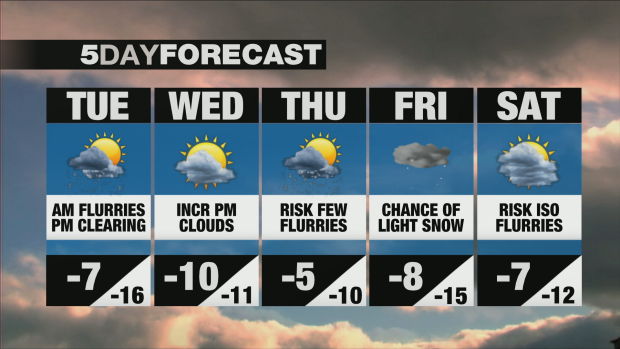
The advice comes ahead of what is expected to be a “bitterly cold” night in Toronto, according to CP24 meteorologist Bill Coulter. “Not only this afternoon, when it's gonna feel around -14 C, -15 C at its warmest, but overnight tonight.”
According to Environment Canada, a low of -16 C is forecasted in Toronto, but the wind chill could make it feel like -25 C.
Toronto’s Cecil Street warming centre, which only opens when the temperature drops below - 15 C, opened its door at 5 p.m. and by 9 p.m., it was already at capacity. It is the fifth warming centre accepting walk-ins. The other four are at 136 Spadina Rd., 75 Elizabeth St., 12 Holmes Ave., and 885 Scarborough Golf Club Rd.
While residents awoke to flurries Tuesday morning, the city says no more than two centimetres of accumulation is expected. In light of the snow, the city is advising residents to keep a safe distance from snow-clearing equipment and to slow down while on the roads or consider taking public transit.
While the morning may have brought messy conditions, the sun is expected to make an appearance in Toronto by Tuesday afternoon, Coulter predicts. That doesn’t mean an end to the cold, however – temperatures in Toronto are forecasted to remain below -5 C into the weekend, with snow once again in the forecast around Friday.
An extreme cold warning is in effect in Caledon, Halton Hills and Milton, with wind chill values near -30 is expected this evening into Wednesday morning.
"Extreme cold warnings are issued when very cold temperatures or wind chill creates an elevated risk to health such as frost bite and hypothermia," Environment Canada said.


