A winter storm swept across southern Ontario Friday evening, bringing heavy snow, strong winds and, in some instances, lightning.
Hundreds of flights were cancelled at Toronto Pearson Airport, and some had to divert to other airports due to the conditions. Snow combined with gusty winds also led to treacherous driving conditions on the road.
Here's what you need to know about the storm, including when conditions will improve.
WARNING ENDS
For most of the evening, Toronto, Peel Region, Durham Region and some areas in Halton Region were under a winter storm warning.
"Snow heavy at times is expected to transition to periods of rain tonight as temperatures rise above freezing," Environment Canada said in its advisory, which was lifted just after 11:30 p.m.
Environment Canada said the storm was expected dump 10 to 25 centimetres of snow by Saturday morning. It added that peak snowfall rates were between that five to eight centimetres per hour.
- Download our app to get alerts to your device
- Sign up to get email alerts from Toronto's Breaking News CP24
In addition to the snow, strong wind gusts were also in the forecast, which reduced visibility significantly.
Several residents also reported seeing lightning as snow fell, a phenomenon commonly called "thundersnow."
Environment Canada said travel should be avoided if possible due to hazardous driving conditions.
FLIGHT DELAYS, CANCELLATIONS
Speaking to CP24 earlier this evening, Sean Davidson, the spokesperson for the Greater Toronto Airports Authority (GTAA), said passengers should expect delays or cancellations due to the snow.
"The airlines are adjusting their schedules to what we can currently accommodate at the airport based off the conditions," he said.
He added that the GTAA collaborates with airlines and NAV Canada to make strategic decisions on airport operations during the storm.
"Those conditions come down to simply making sure that the runways are clear enough for us to be able to land and take off planes. There's a massive airfield that we deal with, and our specialized snow equipment needs to get out there and have the time to get out there to clear that snow before planes can take off and land," Davidson said.
"So there's a lot of complexities that go into making sure that the runways, taxiways, aprons are safe for planes to depart."
On Friday, the airport confirmed a total of 193 cancelled flights, including both arrivals and departures. However, in a statement sent to CTV News, the Greater Toronto Airports Authority (GTAA) said that it cannot confirm what portion of the cancelled flights were due to weather.
“…We can’t specify what portion of them were due to weather – other issues would include any mechanical, staffing, or any other factors elsewhere that day. For sure, the weather in Chicago and Toronto contributed to a majority of them.”
In addition, 56 aircrafts were serviced by the airport’s central deicing facility (CDF) during the storm, averaging 16 minutes per-plane.
POLICE URGE CAUTION
As the snow began to fall, police reminded motorists to drive with caution and ensure that their vehicles were storm-ready.
"There is a potential for some significant accumulation of snow and rain will certainly make it challenging as well," Ontario Provincial Police Sgt. Kerry Schmidt said in a video posted on social media.
"Those wind gusts can often take you by surprise if you're going down the highway. Give yourself lots of distance behind traffic in front of you. Make sure you're aware of your surroundings. Share the road safely and responsibly."
Police in Toronto and Peel reported incidents of falling debris and downed utility and light poles due to strong winds.
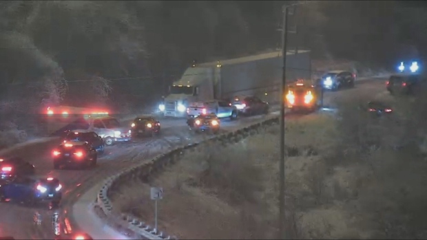
There were also reports of drivers being stuck on snow-covered hills. An ambulance was forced to turn around on Don Mills Road near the Don Valley Parkway because it was blocked by vehicles struggling in the snow.
WHEN WILL THE STORM END
According to Environment Canada, some areas would see snow transition to periods of rain overnight or early Saturday morning. However, rain will change to periods of snow later in the morning as cold air sweeps in.
"In the wake of this system, much colder Arctic air will become established across the region," the federal weather agency said.
"A multi-day lake effect snow event is expected for locations east of the Great Lakes, bringing additional snowfall accumulations to some communities."
In Toronto, local blowing snow is possible early Saturday afternoon as strong winds move in. The city could see an additional snowfall amount of two centimetres.
The temperature will fall from a high of 2 C to -2 C in the afternoon with a wind chill of -10.
Conditions are expected to improve in the evening. Next week, temperatures are expected to drop below zero, to a low of -13 C on Tuesday.


