A winter storm rolled into Toronto on Wednesday, bringing snow and ice pellets.
The wintry mix led to tricky road conditions for the evening commute and flight delays and cancellations at Toronto Pearson airport.
The city could see between 15 to 20 centimetres of accumulation by the time the storm passes through the region on Thursday morning.
11 p.m.
A winter storm warning remains in effect for Toronto.
CP24 Meteorologist Chris Potter says Toronto will continue to see snow and ice pellets in the next several hours, but conditions will improve before daybreak on Thursday.
"Everything will wander eastward rapidly as we get into the second half of the overnight. I would say between 2 and 3 a.m. That's when it will rapidly clear off towards the east. Once we get through the snow, no more accumulating snow is expected," Potter said.
As for Thursday, Potter says the city will see a few flurries from time to time. In the afternoon, some patchy light freezing drizzle is expected.
MORE: School, bus cancellations in effect Thursday as Ontario gets hit with snowstorm
According to Environment Canada, Toronto will see a mix of sun and cloud on Friday, with a high of -6 C and an overnight low of -13 C.
It will be mostly cloudy this weekend, with a chance of flurries. The high for Saturday will be -3 C, while a high of 2 C is in the forecast for Sunday.
10:00 p.m.
Several vehicles are stuck in the snow on Avenue Road, north of Dupont Street. Many vehicles are seen struggling to drive up the hilly road, which has not been plowed.
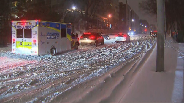
In Brampton, Peel police tweeted that a number of vehicles were stuck in the snow in the area of Mississauga Road and Embleton Road. They are urging drivers to avoid the area and use alternate routes.
8:25 p.m.
As the storm starts to blow through southern Ontario, Ontario Provincial Police (OPP) remind drivers to exercise caution when hitting the road.
"Please be careful out there.The salters and plows are trying to keep the highways open. The less traffic that's out there, the easier it is for them to get their runs done, to get those highways plowed and salted," OPP Sgt. Kerry Schmidt said in a video posted to Twitter.
6:05 p.m.
Toronto Pearson International Airport warned travellers on Twitter to check their flight status before trekking to the airport, adding delays are possible.
At this time, 18 per cent of Pearson's scheduled departures are cancelled, while roughly 23 per cent of arrivals are cancelled.
5:15 p.m.
Ontario Provincial Police Sgt. Kerry Schmidt says officers have responded to a dozen of crashes so far, but none were serious. He is urging those driving home to be careful, as road conditions could deteriorate quickly.
"If you think the roads are just bare and dry, once that rain and freezing rain hits, that can lead to some pretty challenging conditions. And obviously, slippery conditions that could result in crashes. So, we just want people to be aware of that. It's going to be a busy night for us," he said.
"And as it gets dark, that's going to be even harder to maybe pick up on what's going on around you. So, again, take it easy, turn your headlights on, and give yourself lots of space. Mother Nature's back at it again."
5 p.m.
The City of Toronto and Toronto police have tweeted out advice to motorists, urging them to be cautious on the road as snow is now steadily falling in the city.
3:50 p.m.
As the afternoon commute gets underway, Durham Regional Police are advising people not to venture out if they don’t have to and to drive according to conditions.
“With deteriorating weather conditions we would like to remind motorists to avoid unnecessary travel,” the force said in a tweet. “If you do have to go out onto the roadways, make sure your car is cleared of snow and ice and take it slow!”
1:10 p.m.
GO Transit says that GO trains will be operating on a reduced and adjusted schedule tomorrow, Thursday, February 23, “to ensure reliability and safety for passengers.”
Customers are also being advised to take extra care while travelling, give themselves extra travel time and to plan ahead. Changes to train schedules will be posted on the GO Transit website.
12:30 p.m.
The TTC says it will mobilize additional operators and vehicles “to ensure minimal impact for customers” as the storm picks up.
The transit agency says surface routes, such as streetcars and buses, are most likely to be impacted by the storm.
Line 3 (the Scarborough RT) is currently operating, but will be closed and fully replaced with buses later this evening, likely around 7 p.m.
As of 5 p.m., the TTC will also temporarily pause service to 41 bus stops in hilly areas in order to minimize the chances that the buses will get stuck in those spots. The full list of affected stops can be found on the TTC’s website.
NOON
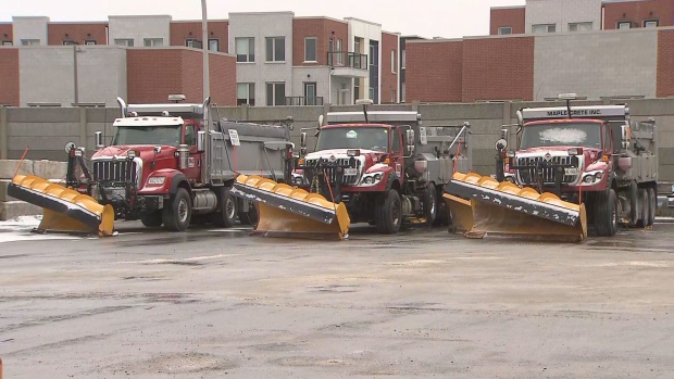
The city says winter operations will be “all hands on deck” over the next day or two in order to deal with the storm.
“We'll be getting our first round of salting in about a few hours,” Vincent Sferrazza, director of operations and maintenance at Transportation Services, told reporters at a noon update.
He said city crews are anticipating a multi-day cleanup operation and advised anyone needing to get around tonight and tomorrow to plan accordingly.
“So if you have to commute we strongly recommend that you try to take transit,” Sferrazza said. “In the event that you're unable to take public transit, then you're gonna have to give yourself plenty of time.”
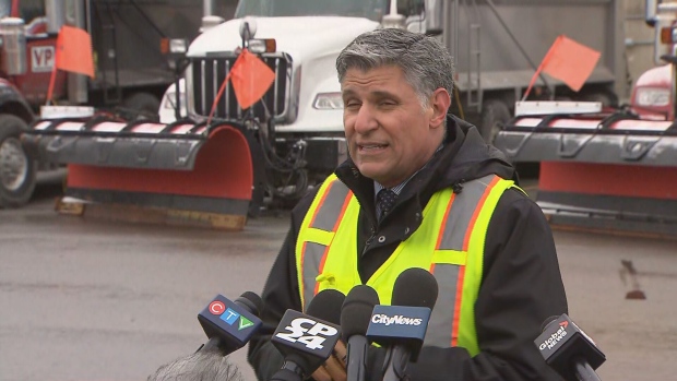
While city crews will be working as fast as they can, there will still be some roads and sidewalks where conditions are slippery or difficult to navigate this evening.
“With all the cars driving it’s going to create that pack snow in some situations where we haven't yet got our salters to those locations,” Sferrazza said. “So they (motorists) are gonna have to take it very slowly and give themselves plenty of time to get home.”
He also advised people not to try and zoom past large salters and plows on the roads as it could be dangerous.
10:45 a.m.
Pearson International Airport is advising passengers to check their flight status before heading to the airport as poor weather conditions could affect flights.
“Delays and cancellations are expected so please check your flight status with your airline,” the airport says on its website.
10 a.m.
Mississauga has suspended temporary parking permits until further notice in order to accommodate winter weather operations. People are being asked to remove parked vehicles from roads so that crews can do their work.
9:55 a.m.
Ontario Provincial Police are warning motorists to be prepared for “some very challenging driving.”
“Please make sure you have your full head lighting system on if you're on the roads,” OPP Sgt. Kerry Schmidt said in a tweet. “Give yourself lots of space behind the vehicle in front of you so you can slow down, change lanes or stop if needed.
“And be aware of how quickly these conditions can change. If we're into freezing rain or ice pellets, the roads may not look treacherous. But they could be very slippery so please be careful out there.”
9:30 a.m.
Periods of light snowfall have begun in the city ahead of the more intense snowfall expected later today. The temperature is sitting at -3, but feels more like -8 with the wind chill.
8:30 a.m.
The storm system is just beginning to move into southwestern Ontario.
There are just flurries in the GTA for now, but that will change later in the day.
CP24 Meteorologist Bill Coulter says it might be worth trying to head home a bit early if possible this afternoon in order to avoid the more intense part of the storm.
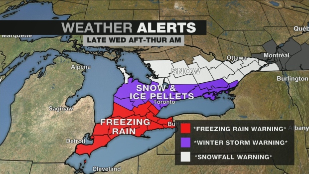
“It will be 5 p.m. when we see the intensity of the storm system really move in. The leading edge of that shield is just moving across the Detroit River into extreme southwestern Ontario where after an initial shot of snow, it'll change over to freezing rain,” Coulter said. “We're in the zone for a Winter Storm Warning, meaning mixed precipitation, likely keeping totals under 15 centimeters. However, if we get more snow than ice pellets that could really push up snow accumulations totals and push us into a Snowfall Warning.”
5:15 a.m.
The Ministry of Transportation is warning people heading out on the roads to be ready to adjust to changing road conditions as the storm moves in later today.
5 a.m.
The city`s Warming Centre at Metro Hall is already open for those seeking shelter from the cold. The city’s other three warming centres are set to open at 7 p.m.
They are at Cecil Community Centre (58 Cecil St.); Mitchell Field Community Centre (89 Church Ave, North York); and Scarborough Civic Centre (150 Borough Dr., Scarborough)
4:50 a.m.
A variety of warnings from Environment Canada are in effect across most of southern Ontario now, including freezing rain warnings, snowfall warnings and winter storm warnings.
In Toronto, a winter storm warning is in effect for the city, though the city could also get other warnings as the day goes on depending on how the storm system develops.
Toronto is expected to see 10 to 15 cm of snow and ice pellets starting in the late afternoon, with a risk of freezing rain as well.


